Tthe Bureau of Meteorology gives the latest weather update. Photo: Screenshot / Bureau of Meteorology
By ABC meteorologist Tom Saunders, Millie Roberts and Brooke Chandler
A major rain event is unfolding across eastern Australia, triggering numerous warnings for heavy rain, flooding and damaging winds.
A severe thunderstorm warning for the Sydney area was cancelled at about 4.30am (AEST) on Friday, however the Bureau of Meteorology (BOM) said the broader severe warning for heavy rainfall and damaging winds was still in place.
Overnight, Thursday's heavy rain spread along the coast bringing heavy falls across NSW, with Sydney affected from midnight with rainfall of about 80 millimetres.
BOM meteorologist Helen Reid said Observatory Hill in the city's centre had the highest rainfall, with over 100mm since 9am yesterday.
"Now we still have that rain coming down and we're expecting that rain to continue and increase during the course of today," she said.
She said the highest rainfall totals were in Sydney itself, but widespread rainfall has been seen throughout coastal NSW.
Houghlahans Creek in the state's north picked up 96mm of rain, while Hamlyn Terrace in the Central Coast experienced over 90mm as well.
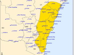
A severe weather warning for intense rainfall and damaging wind gusts is also in place from Morisset near Newcastle, down to Bega as of Friday morning.
The NSW State Emergency Service (SES) has warned people in affected areas to stay indoors under a watch and act alert for severe weather and the risk of flash flooding.
"The areas affected are likely to change during the course of today, so keep up to date with [warnings]," Reid added.
Severe Weather Update for #NSW, southern #Qld and eastern #Victoria, where heavy rain is forecast. #Flood Watches are also in place. Video current: 11:30am AEDT 4 April 2024.
— Bureau of Meteorology, Australia (@BOM_au) April 4, 2024
Latest forecasts and warnings: https://t.co/4W35o8iFmh or the BOM Weather app. pic.twitter.com/cWukVbNBAP
SES warns drivers to avoid trips
Premier Chris Minns said it was a "significant weather event".
"It is most important that you don't take unnecessary risks at the moment, particularly travelling through flood waters," he said.
NSW SES Commissioner Carlene York said many roads in rain-affected parts of the state were dangerous and warned people to avoid unnecessary trips.
"The SES are putting out lots of warnings to be ready to our communities … particularly the metropolitan area and out around Hawkesbury/Nepean area," she said.
"When you are driving around … you never know exactly where the water will fall and what effect that will have on the roads."
She said people in low-lying areas should have a plan for evacuation in case that was required.
Intense rainfall to move to Victorian border
The significant weather system is expected to move south-east and out into the Tasman Sea on Sunday, the BOM's Steve Bernasconi said.
In the meantime, severe weather warnings are still in place for heavy rain and "likely intense falls".
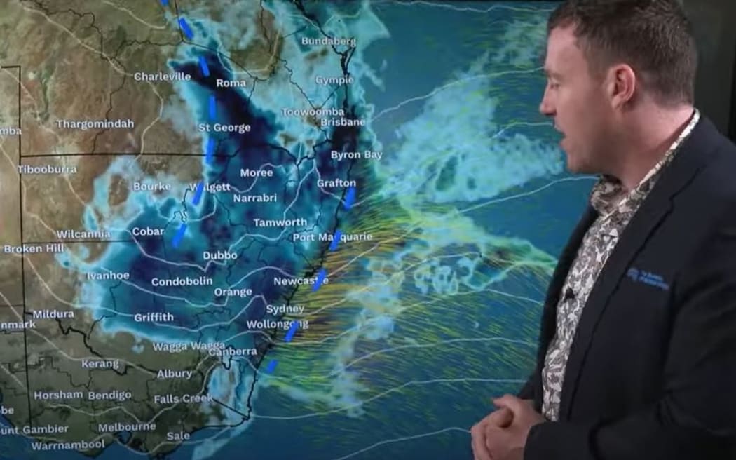
The mass of heavy rain will then expand slowly south today - at its peak extending from southern Queensland right down to the Victorian border.
While many regions can expect heavy falls and flooding the most intense rain will impact the NSW coast and ranges from the Central Coast to the South Coast from Friday afternoon to early Saturday, with the BOM forecasting 24 hour totals of 70 to 120mm, reaching up to between 100mm to 300mm in some areas around the Blue Mountains and Illawarra Escarpment.
The widespread deluge is the result of a humid airstream off the Coral and Tasman seas feeding into cold air over the eastern inland - this volatile mix of contrasting air masses is leading to a rapid reduction in surface pressure with two rain-producing troughs forming; one inland and another along the coastline.
Minns said the Warragamba Dam was sitting at over 96 per cent of its supply capacity this morning.
"We require about 90mm of rain to fill [the dam] … we're expecting 100 to 150mm of rainfall over that catchment as a result of this event," he said.
This means the dam will likely spill on Monday, the premier said.
By 9am on Thursday, several locations across southern Queensland and northern NSW had already received more than 100mm, including 219mm at Nashua, near Lismore, the area's heaviest fall in two years.
Rain intensified further through the day, with up to 28mm falling in just one hour on the outskirts of Brisbane by midday and 112mm at Surrey by 6pm.
Coastal regions from the escarpment up to the southern Queensland will continue to be in for another wet 24 hours, the BOM said.
However, a band of torrential rain and storms could develop within the broader rainband, producing life-threatening flash flooding between the Blue Mountains and Narooma, a deluge that could produce six-hourly rainfall totals between 90 to 150mm, climbing to 220mm over the Illawarra Escarpment.
Rain and thunderstorms through the weekend
A flood watch has been issued for at least 50 rivers in eastern NSW and southern Queensland from the Condamine-Ballone to the Towamba, including a major flood threat along the Hawkesbury-Nepean where a near-full Warragamba Dam will have a limited capacity to hold back flows through Western Sydney.
A minor warning for possible flooding is still in place for the Richmond River, Paroo River, Gwydir River and Wilsons River.
The heaviest rain should then contract to the South Coast through Saturday, although showers and thunderstorms will still fire up over much of the state through the weekend.
Along with heavy rain and flooding the deepening troughs will also strengthen winds, prompting a warning for damaging gusts to around 90km/h along the coastal strip south from Sydney.
This story was originally published by the ABC.