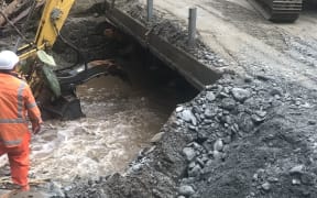
Photo: Marika Khabazi
The past couple of days have seen severe weather nationwide, and more rain to come this weekend.
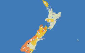
MetService said while the orange rain warning expired on Friday for the top of the South Island, it expected more heavy rain in the region on Saturday from about dawn to late afternoon.
Rain amounts could approach warning criteria.
MetService meteorologist Mmathapelo Makgabutlane said a low pressure system would move across the country on Saturday bringing more areas of wet weather.
"That low pressure system also moves across with some windy conditions and we've also got some strong winds expected especially over central and lower parts of the North Island where we've got some strong wind watches in place."
A heavy rain watch was in place for Mount Taranaki until 6pm Saturday, Tasman northwest of Motueka until 3pm Saturday and the Tararua Range until 9pm Saturday.
A wind watch was in place for South Taranaki coast, coastal Whanganui, Manawatu and Tararua District until 10pm Saturday.
During Saturday afternoon, there was a moderate risk of thunderstorms in the west from Taranaki to northern Wellington, and extending to Wairarapa.
MetService said if they occur, the thunderstorms could bring localised heavy rain of 10 to 25 millimetres per hour, small hail, and strong wind gusts of 90 to 110 kilometres per hour.
The good news was the end was in sight, Makgabutlane said.
On Sunday, the weather was expected to settle down quite a lot as the low pressure system moves off the country.